
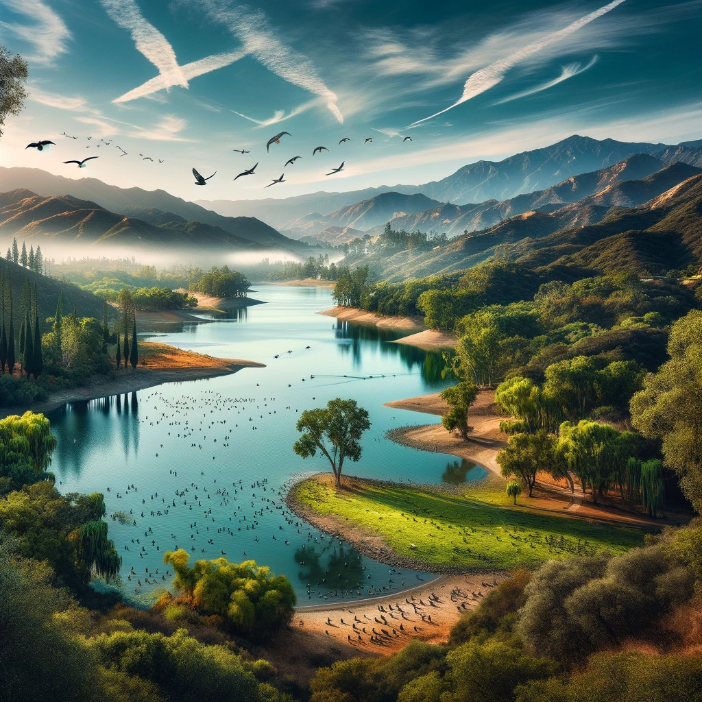
Introduction to Lake Cachuma’s Hydrological Status A crucial reservoir in California, United States, stood at a Lake Cachuma water level of 752.42 feet as of February 28, 2024. This significant water body not only serves as a primary source of water for the surrounding communities but also as a recreational destination. The fluctuations in its water level are of great interest due to their impact on local water supply, ecological health, and recreational activities. Historical Lake Cachuma Water Levels and Recent Trends Historically, Lake Cachuma has experienced periods of both abundance and scarcity. The reservoir reached full capacity in early 2023, a rare event that last occurred over a decade prior. This replenishment was attributed to consecutive storms, demonstrating the lake’s vulnerability to climatic variations. Such events underscore the importance of effective water management in sustaining the reservoir’s health and utility. Comparative Analysis with Other Regional Lakes When compared to other regional reservoirs, such as Lake Casitas, which had a volume of 217,994 acre-feet, the variability in water levels across different lakes becomes evident. These differences highlight the localized nature of water resources and the need for tailored management strategies to address the unique challenges each reservoir faces. Spillage History and Water Management Implications Lake Cachuma’s spillage history, with the last event in 2011, points to the dynamic nature of its water level. Spillage events are significant as they influence downstream water availability and ecosystem health. The management of these events, particularly in anticipation of storms, is crucial for preventing potential flooding and ensuring sustainable water storage. Recreational Use and Environmental Considerations Aside from its utility as a water source, Lake Cachuma is a popular recreational area. Activities like boating and fishing attract visitors, contributing to the local economy. The prohibition of swimming to protect water quality for consumption illustrates the delicate balance between recreational use and the reservoir’s primary function as a water supply source. The Creation and Evolution of Lake Cachuma The creation of Lake Cachuma in the 1950s was a transformative event for Santa Barbara County, marking a significant human intervention in the region’s natural landscape. The reservoir’s evolution since then reflects broader trends in water resource management, including the challenges of ensuring reliable water supply amidst fluctuating environmental conditions. Water Distribution and Utilization The water from Lake Cachuma is distributed through intricate infrastructure, like the Tecolote Tunnel and South Coast Conduit, facilitating its use across Santa Barbara’s southern coast. This distribution system underscores the complexity of managing water resources in a way that balances regional needs with sustainable practices. Biodiversity and Ecological Impact Lake Cachuma’s ecological significance cannot be overstated. It supports a diverse range of species, particularly bird populations that rely on the reservoir for habitat. The management of the lake’s fish population, through practices like stocking, plays a crucial role in maintaining the ecological balance and supporting recreational fishing. Impact of Spill Events on Ecosystem and Community The historical spill events at Lake Cachuma have had profound impacts on the downstream ecosystem and water availability. Managing these events to mitigate potential negative effects while optimizing water storage capabilities highlights the complexities of reservoir management in response to natural climatic fluctuations. Future Prospects and Sustainability Looking forward, the management of Lake Cachuma’s water level will continue to be a critical issue. Balancing the needs for water supply, recreational use, and ecological preservation requires a forward-thinking approach that anticipates future challenges. Sustainable practices, informed by historical data and current trends, will be essential in securing the long-term viability of Lake Cachuma as a vital water resource. Conclusion Lake Cachuma’s significance extends beyond its immediate utility as a water reservoir. It plays a central role in the regional water management strategy, supports diverse recreational activities, and contributes to local biodiversity. Understanding and managing its water level is crucial for ensuring the sustainability of this vital resource, reflecting the broader challenges and responsibilities in managing water resources in California. FAQs about Lake Cachuma What is the current water level of Lake Cachuma? As of February 28, 2024, the water level at Lake Cachuma was 752.42 feet. Is Lake Cachuma currently full? Yes, as of early 2024, Lake Cachuma reached full capacity, benefiting from significant rainfall and storms in the region. When did Lake Cachuma last reach full capacity before 2024? The lake was last full in early 2023, which was the first time it had reached full capacity in 12 years. Can you swim in Lake Cachuma? No, swimming in Lake Cachuma is not allowed as it is a drinking water reservoir. However, there are swimming pools available for visitors in the recreation area. Why can’t I swim in Lake Cachuma? Swimming is prohibited in Lake Cachuma to maintain the quality of the water, which serves as a vital drinking source for the local community. How does Lake Cachuma compare to other lakes in California in terms of water level? Lake Cachuma’s water level fluctuates based on rainfall and water management practices. It can be compared with other California lakes like Lake Casitas, but each lake’s level depends on local conditions and management strategies. What kind of recreational activities are available at Lake Cachuma? Recreational activities include boating, fishing, hiking, and bird-watching. There are also picnic areas and camping facilities available for visitors. Where does the water from Lake Cachuma go? Water from Lake Cachuma is diverted through the Tecolote Tunnel to the South Coast Conduit, providing water to the South Coast region of Santa Barbara County. What types of fish can be found in Lake Cachuma? Lake Cachuma is home to various fish species, including rainbow trout, catfish, bass, and crappie. When was Lake Cachuma created? Lake Cachuma was created in the early 1950s with the completion of the Cachuma Dam. How deep is Lake Cachuma? Lake Cachuma has a maximum depth of 46 meters (approximately 151 feet). Are there any wildlife conservation efforts at Lake Cachuma? Yes, there are conservation efforts in place to protect the diverse wildlife around Lake Cachuma, especially for
Research about Crowley Lake Stone Columns
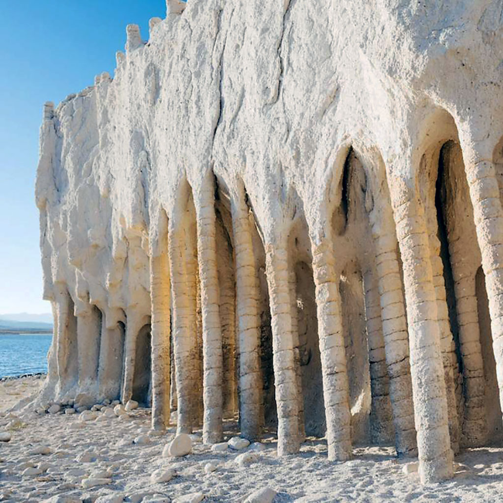
How to Reach the Magnificent Crowley Lake Stone Columns Embarking on a journey to witness the mesmerizing Crowley Lake Stone Columns is an adventure in itself. The journey begins by preparing for the trip, ensuring you have all necessary supplies. Travel along U.S. Route 395 and turn onto Owens Gorge Rd. Following the signs and staying on Owens Gorge Rd for about 4 miles will lead you to Crowley Lake. Crossing the Long Valley Dam, you will find yourself at the trailhead, where a guide can help you reach the columns. Best Time to Visit The Crowley Lake columns offer a breathtaking spectacle best enjoyed from May through October. This period ensures a pleasant experience, free from the harsh winter conditions. With its popularity among hikers and off-road enthusiasts, expect some company as you explore. Parking is available in a small, unmarked loop area from where the columns are accessible by foot. The Enigma of Crowley Lake’s Name Crowley Lake is named after J.J. Crowley, a Catholic priest, reflecting the near-spiritual allure of the area, especially during the fishing season opener in April. This event draws thousands of anglers, making it a significant occasion at the lake. Unveiling the Mystery of California’s Most Mysterious Lake The Crowley Lake Columns, first noticed after the completion of the Crowley Lake reservoir in 1941, stand as an enigmatic feature on its eastern shore. These columns, with their regular intervals of cracks, resemble Moorish temples, sparking curiosity and awe. Operational Hours and Recreational Activities Crowley Lake is open daily from 7 am to 9 pm. The gate closure each evening is a precaution for the quagga mussel inspection. The lake is a hub for various recreational activities, including boating, swimming, and fishing, offering a complete outdoor experience. The Rich History of Crowley Lake Around 700,000 years ago, volcanic eruptions dramatically shaped the area, creating a landscape that would eventually host Crowley Lake. The construction of the Long Valley Dam in 1941 by the City of Los Angeles transformed the region, creating the lake as we know it today. The Depths of Crowley Lake Crowley Lake, with its extensive shoreline and significant depth, provides an ideal habitat for trout and other wildlife, contributing to its popularity among anglers. Understanding Crowley Lake’s Fluctuating Levels The water level at Crowley Lake is influenced by various factors, including drought conditions and seasonal changes, affecting its recreational appeal and ecological balance. Geological and Hydrological Insights Crowley Lake, formed by the damming of the Owens River Gorge, plays a crucial role in the region’s water management and provides a scenic spot for outdoor enthusiasts. Crowley Lake’s Elevation and Population Situated at an elevation of 6,949 feet, Crowley Lake is a small community with a rich natural and cultural heritage, offering a serene escape in California’s Mono County. Fishing at Crowley Lake The fishing season at Crowley Lake is a much-anticipated event, with specific regulations in place to ensure sustainable and enjoyable angling experiences. Crowley Lake’s Capacity and Significance With a substantial storage capacity, Crowley Lake serves as a vital resource for irrigation, municipal water supply, and recreational activities, highlighting its importance in the region’s ecosystem and community life. Crowley Lake Stone Columns stand as a testament to nature’s artistry and human curiosity, inviting visitors to explore and marvel at its geological wonders. Frequently Asked Questions about Crowley Lake Stone Columns 1. What are the Crowley Lake Stone Columns? The Crowley Lake Stone Columns are natural rock formations on the eastern shore of Crowley Lake in California. They are characterized by tall, columnar structures with distinctive horizontal striations. 2. How were the Crowley Lake Stone Columns formed? The columns were formed through a process of erosion and frost wedging. The theory is that hot volcanic ash fell into the cold water of the lake, causing the ash to cool and contract quickly, forming the columns. 3. Can I visit the Crowley Lake Stone Columns? Yes, visitors can access the columns. However, reaching them involves a bit of hiking or off-road driving. It’s important to respect the natural environment and adhere to local guidelines while visiting. 4. Is there a specific time of year that is best for visiting the columns? The best time to visit the Crowley Lake Stone Columns is from May through October. During this period, the weather is more favorable for hiking and the road conditions are better. 5. Do I need a permit to visit the Crowley Lake Stone Columns? No specific permit is required to visit the columns, but it’s important to check the local regulations and any access restrictions that might be in place during your visit. 6. How long is the hike to reach the Crowley Lake Stone Columns? The hike to reach the columns can vary depending on the starting point, but generally, it involves a few miles of hiking. Some trails may require off-road driving to get closer to the columns. 7. Are there guided tours available to see the Crowley Lake Stone Columns? While there may not be regular guided tours specifically for the stone columns, local tour operators might include a visit to the columns as part of their broader tour packages in the area. 8. What should I bring when visiting the Crowley Lake Stone Columns? It’s advisable to bring water, sunscreen, appropriate hiking footwear, and possibly a camera to capture the stunning scenery. Also, check the weather forecast and prepare accordingly. 9. Is fishing allowed at Crowley Lake? Yes, fishing is a popular activity at Crowley Lake. The lake is known for its trout fishing, especially during the fishing season which starts the last Saturday in April. 10. What other activities can be done at Crowley Lake besides visiting the stone columns? Besides visiting the stone columns, you can engage in activities like fishing, boating, camping, and bird watching. The area around Crowley Lake offers a natural setting for various outdoor activities.

Shark Fin Cove: A Hidden the Pacific Coast
Shark Fin Cove, also known as Shark Fin Cove, is a breathtakingly beautiful spot nestled along the Pacific Coast near Davenport, California. Situated just a short drive from Santa Cruz on the scenic Highway 1, this cove is a must-visit for anyone exploring the California coastline. Named after its iconic shark-fin-shaped rock that juts out from the ocean, Shark Fin Cove offers visitors a unique and picturesque landscape that is perfect for photography, nature walks, and peaceful beach outings. The Allure of Shark Fin Cove The allure of Shark Fin Cove lies in its natural beauty and the variety of activities it offers. Visitors can enjoy: Swimming and Beachcombing: The cove’s beach is ideal for a relaxing swim or a stroll along the shore. The clear waters and gentle waves make it a pleasant spot for a dip, while the sandy beach is perfect for beachcombing and picnicking. Exploring Sea Caves and Tunnels: At low tide, adventurous visitors can explore the sea caves and the old mining tunnel that adds to the cove’s mystique. These natural formations provide a unique opportunity to witness the power of the ocean up close. Hiking for Sunset Views: For those who love hiking, there are trails at the top of the cove that offer stunning views of the ocean and the surrounding landscape. These trails are particularly popular during sunset when the sky is ablaze with colors. Photography Opportunities: Shark Fin Cove is a photographer’s paradise. The striking rock formation, combined with the changing tides and light conditions, creates a dynamic and dramatic setting for photography. Planning Your Visit To make the most of your visit to Shark Fin Cove, keep the following tips in mind: Check the Tide: The cove is best accessed during low tide when the beach is more exposed, and the sea caves are accessible. Stay Safe: The cliffs around the cove can be steep and unstable. Stick to marked trails and be cautious near the edge. Respect the Environment: Help preserve the natural beauty of Shark Fin Cove by respecting wildlife, not leaving any trash behind, and adhering to local regulations. How to Get There Shark Fin Cove is accessible via Highway 1, about 15 minutes north of Santa Cruz. Visitors can park along the highway and follow a short trail that leads down to the cove. The trail includes some steep sections and abandoned railway tracks, so sturdy footwear is recommended. Conclusion Shark Fin Cove is a hidden gem along the Pacific Coast that offers visitors a chance to immerse themselves in the natural beauty of California’s coastline. Whether you’re looking for a peaceful beach day, an adventurous exploration of sea caves, or the perfect sunset photography spot, Shark Fin Cove has something for everyone. Just remember to visit during low tide and respect the natural environment to ensure a safe and enjoyable experience. FAQs about Shark Fin Cove Q1: Is there an entrance fee to visit Shark Fin Cove? A1: No, there is no entrance fee to visit Shark Fin Cove. It is a public beach accessible to everyone. Q2: Are there any facilities available at Shark Fin Cove? A2: Shark Fin Cove is a natural, undeveloped area, so there are no restrooms, showers, or other facilities available. Visitors should plan accordingly and bring any necessary supplies. Q3: Is it safe to swim at Shark Fin Cove? A3: Swimming at Shark Fin Cove can be safe, but it’s important to be cautious of the ocean currents and tides. Always check the local weather and tide conditions before entering the water, and swim at your own risk. Q4: Can I bring my dog to Shark Fin Cove? A4: Dogs are allowed at Shark Fin Cove, but they must be kept on a leash at all times. Please be responsible and clean up after your pet. Q5: How long is the hike to get to the beach? A5: The hike from the parking area to the beach is relatively short, but it can be steep in some sections. It typically takes about 5-10 minutes to reach the beach from the highway. Q6: Is Shark Fin Cove suitable for children? A6: Shark Fin Cove can be a fun place for children to explore, but parents should keep a close eye on them, especially near the cliffs and the ocean. The terrain can be uneven, and the waves can be unpredictable. Q7: Can I have a picnic at Shark Fin Cove? A7: Yes, picnicking is allowed at Shark Fin Cove. However, there are no picnic tables or trash cans, so be sure to pack out everything you bring in to keep the area clean. Q8: Are there any hiking trails nearby Shark Fin Cove? A8: Yes, several hiking trails in the area surrounding Shark Fin Cove offer stunning views of the coastline. Some popular nearby trails include the Davenport Bluff Trail and the Coastal Trail. Q9: Is Shark Fin Cove crowded? A9: Shark Fin Cove can get crowded, especially on weekends and during the summer months. It’s best to visit early in the morning or on weekdays if you’re looking for a more peaceful experience. Q10: Are there any restrictions on photography at Shark Fin Cove? A10: There are no specific restrictions on photography at Shark Fin Cove, but visitors are encouraged to be respectful of the natural environment and other visitors while taking photos. Drones may be subject to local regulations, so check the rules before flying one.

Tornado Killeen Texas: Understanding the Impact and Preparing for the Unpredictable
Tornadoes are a relentless force of nature that can strike with little warning, leaving a trail of destruction in their wake. Killeen, Texas, is no stranger to the havoc wrought by these violent storms. This blog delves into the impact of tornadoes in Killeen and across Texas, shedding light on the importance of preparedness and resilience in such unpredictable events. The Menace of Tornadoes in Texas Texas is notorious for its susceptibility to tornadoes, with the state recording the highest average number of twisters annually. The geography and climate of Texas create a perfect storm for tornado formation, especially during the peak tornado season from April to June. The Dallas-Fort Worth Metroplex: A Hotspot for Tornado Activity The Dallas-Fort Worth Metroplex stands out as a particularly tornado-prone region in Texas. Since the beginning of the 21st century, this area has reported 81 tornadoes, with 13 classified as EF-2 or higher. The financial toll of these tornadoes is substantial, with damages reaching $2.6 billion, underscoring the significant impact of these natural disasters. Tornadoes in 2022: A Reminder of Nature’s Fury The year 2022 was a stark reminder of the constant threat posed by tornadoes in Texas. Notable tornadoes on March 21 included an EF2 tornado with a path length of 27.39 miles and an EF1 tornado that carved a path of 2.46 miles. These events serve as a reminder of the importance of vigilance and preparedness. Tornadoes in Killeen, Texas: A History of Destruction Killeen has not been spared the wrath of tornadoes. The city has witnessed several significant tornado events, with the most severe being an EF3 tornado in 2022. The impact of such events is profound, affecting communities and individuals in numerous ways. The Importance of Tornado Preparedness Given the frequency and unpredictability of tornadoes in Texas, preparedness is key. Residents should have a clear plan in place for seeking shelter during a tornado, such as in a basement or an interior room without windows on the lowest floor. Awareness of the signs of an approaching tornado, like a loud roar or a greenish sky, can also help people take timely action to protect themselves. The Role of Technology in Tornado Safety Advancements in technology have significantly improved tornado detection and warning systems. Weather apps, emergency alerts, and social media platforms play a crucial role in disseminating real-time information about tornado threats. Staying informed through these channels can make a critical difference in ensuring safety during a tornado. Conclusion: Building Resilience in the Face of Tornadoes Tornadoes are an inescapable reality in Texas, and Killeen has experienced their destructive power firsthand. As the state continues to face the challenges posed by these natural disasters, the importance of preparedness and resilience cannot be overstated. By staying informed, having a plan, and utilizing available technology, residents can enhance their safety and mitigate the impact of tornadoes. The community’s collective efforts in building resilience will be the key to weathering the storms that lie ahead. Frequently Asked Questions (FAQs) about Tornadoes in Killeen, Texas 1. What is a tornado? A tornado is a rapidly rotating column of air that extends from a thunderstorm to the ground. It is often visible as a funnel-shaped cloud and can cause significant damage along its path. 2. How common are tornadoes in Killeen, Texas? Tornadoes are relatively common in Texas, including the Killeen area. The state experiences an average of 135 tornadoes annually, and Killeen has faced several significant tornado events in recent years. 3. What was the most severe tornado to hit Killeen, Texas? One of the most severe tornadoes to hit Killeen was an EF3 tornado in 2022. This tornado caused considerable damage, highlighting the importance of preparedness in the region. 4. How can I stay informed about tornado warnings in Killeen, Texas? Residents can stay informed about tornado warnings through various channels, including weather apps, local news stations, the National Weather Service, and emergency alert systems on smartphones. 5. What should I do if a tornado warning is issued for Killeen, Texas? If a tornado warning is issued, seek shelter immediately in a basement or an interior room on the lowest floor of a sturdy building. Avoid windows and cover your head and neck to protect yourself from flying debris. 6. Are there any specific safety tips for tornadoes in Killeen, Texas? In addition to seeking shelter, it’s important to have an emergency kit ready, including water, non-perishable food, a flashlight, batteries, a first aid kit, and important documents. Practice your tornado safety plan with your family regularly. 7. How can I help my community prepare for tornadoes in Killeen, Texas? You can help your community by promoting awareness about tornado safety, participating in local emergency preparedness programs, and volunteering with disaster response organizations. 8. What is the difference between a tornado watch and a tornado warning? A tornado watch means that conditions are favorable for tornadoes to form, while a tornado warning means that a tornado has been sighted or indicated by weather radar, and immediate action is necessary. 9. How can I protect my property from tornado damage in Killeen, Texas? To protect your property, consider installing storm shutters, reinforcing garage doors, securing outdoor objects, and ensuring that your home is properly insured against tornado damage. 10. What should I do after a tornado has passed in Killeen, Texas? After a tornado, check for injuries and provide first aid if necessary. Avoid downed power lines and report them to authorities. Assess your property for damage and contact your insurance company to file a claim if needed. Follow instructions from local officials for further safety measures.
Welcome to Barcelia: A Sanctuary of Natural Beauty and Historical Charm
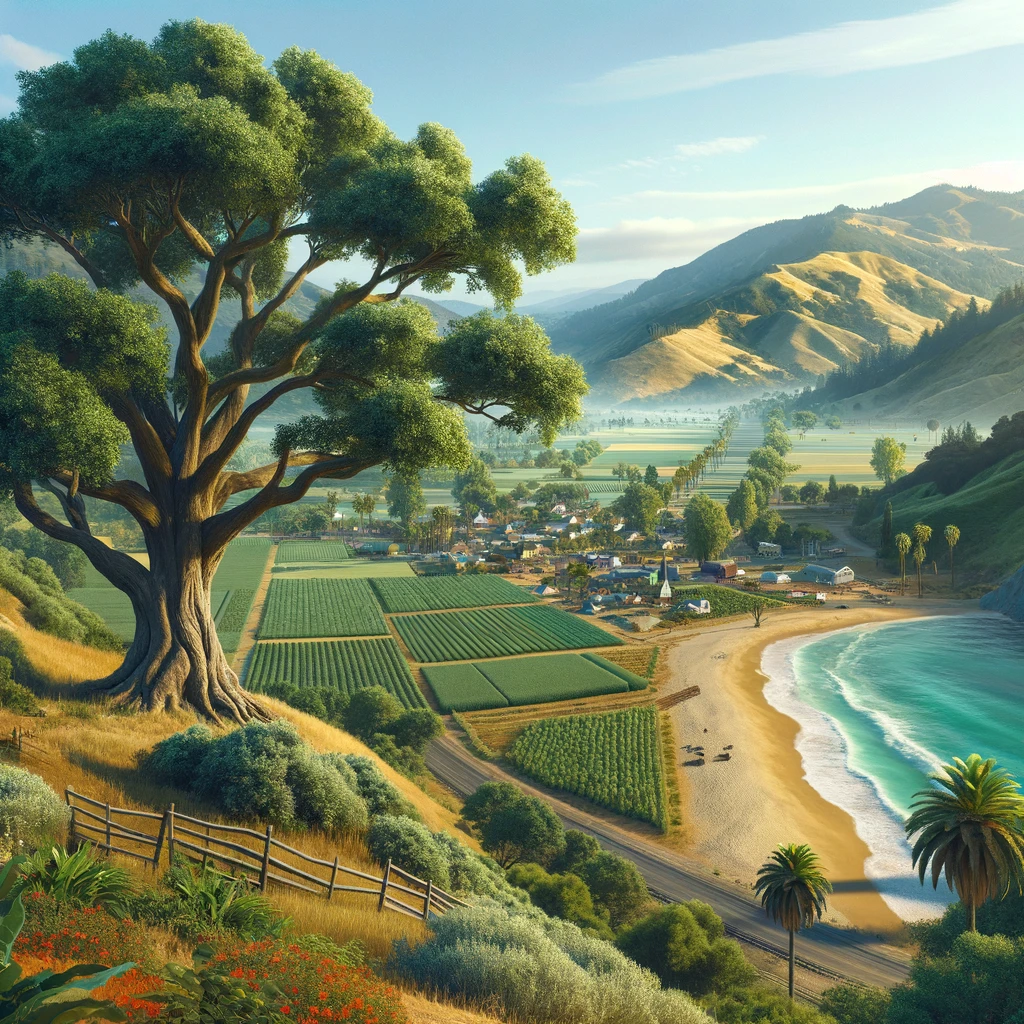
Nestled in a picturesque valley, Barcelia is a hidden gem that captivates the hearts of all who visit. Known for its breathtaking landscapes, vibrant community, and rich heritage, this charming town offers a diverse array of experiences for both adventure seekers and history enthusiasts. From exploring the great outdoors to delving into the past, Barcelia is a destination that promises unforgettable memories. Tracing the Roots of Barcelia: A Historical Perspective The origins of Barcelia can be traced back to the early days of settlement in the region, with Native American tribes being the first inhabitants. They revered the valley oak, a majestic tree that symbolizes Barcelia’s deep-rooted history and connection to nature. The Valley Oak: A Testament to Barcelia’s Natural Splendor The valley oak, or Quercus lobata, is not just a tree in Barcelia; it’s a living monument that is a testament to the town’s natural splendor. With its wide-reaching branches and robust trunk, the valley oak symbolizes strength and resilience, playing a crucial role in the local ecosystem and serving as a habitat for various species. Barcelia’s Agrarian Heritage: A Celebration of Farming and Ranching Agriculture is the lifeblood of Barcelia, with a long-standing tradition of farming and ranching that has shaped the town’s identity. The fertile soil and favorable climate create an ideal environment for growing various crops and raising livestock. From fresh produce to dairy and meat products, Barcelia’s farms are a testament to the town’s commitment to sustainable agriculture and farm-to-table practices. Confronting Environmental Challenges: A Commitment to Sustainability As Barcelia evolves, it faces environmental challenges that require collective action and sustainable solutions. Issues such as pollution, deforestation, and habitat destruction pose threats to the town’s natural beauty and biodiversity. The community actively addresses these challenges through conservation efforts, sustainable development initiatives, and educational programs to ensure a harmonious coexistence with nature. Discovering Barcelia’s Attractions: A Mosaic of Cultural and Natural Wonders Barcelia’s allure extends beyond its natural beauty to encompass a rich tapestry of cultural attractions and points of interest. The Barcelia Museum is a treasure trove of history, offering insights into the lives of the indigenous people and the stories behind their artifacts. Other attractions include art galleries, historic landmarks, and community events celebrating Barcelia’s diverse heritage and vibrant spirit. Conclusion: An Invitation to Explore Barcelia’s Hidden Treasures Barcelia is more than just a destination; it’s a journey into the heart of nature and culture. With its stunning landscapes, historical depth, and warm community, Barcelia offers a unique experience that resonates with all who visit. As the town continues to preserve its roots while embracing the future, it stands as a beacon of sustainability and cultural richness. Whether seeking adventure, relaxation, or inspiration, Barcelia invites you to uncover its hidden treasures and create lasting memories in this enchanting corner of the world. Frequently Asked Questions (FAQs) About Barcelia What is Barcelia known for? Barcelia is renowned for its picturesque landscapes, rich historical heritage, and vibrant community. It’s also famous for its agricultural traditions, particularly its ranches, and farms, and the iconic valley oak, symbolizing the town’s deep connection to nature. How can I get to Barcelia? Barcelia is accessible by car and is located near major highways. The nearest airport is in the closest major city, from which you can rent a car or take a bus to the town. Detailed directions and transportation options can be found on the town’s official website or by contacting local travel agencies. What are the best times to visit Barcelia? The best times to visit Barcelia are during the spring and fall seasons when the weather is mild, and the natural scenery is most vibrant. However, the town offers unique attractions and events throughout the year, making it a great destination regardless of the season. What outdoor activities are available in Barcelia? Barcelia offers a variety of outdoor activities, including hiking, bird watching, cycling, fishing, and picnicking in its beautiful parks and nature reserves. The town is also a popular spot for water sports in its nearby lakes and rivers. What kind of accommodations are available in Barcelia? Barcelia offers a range of accommodations to suit different preferences and budgets. Visitors can choose from cozy bed and breakfasts, charming guesthouses, comfortable hotels, and camping sites for those who wish to immerse themselves in nature. Are there any cultural events or festivals in Barcelia? Barcelia hosts several cultural events and festivals annually, celebrating its rich history and community spirit. These include music and art festivals, agricultural fairs, and historical reenactments, giving visitors a glimpse into the town’s traditions and lifestyle. What dining options are available in Barcelia? Barcelia boasts a variety of dining options, ranging from casual cafes to fine dining restaurants. Many establishments feature locally sourced ingredients and traditional recipes, offering a taste of the region’s culinary delights. Can I find local products and souvenirs in Barcelia? Yes, Barcelia is home to local markets and shops where you can find a variety of products made from the region’s agricultural produce, as well as handmade crafts and souvenirs that reflect the town’s cultural heritage. What is the significance of the valley oak in Barcelia? The valley oak is a symbol of Barcelia’s natural heritage and represents the town’s commitment to preserving its environment. It is also an important ecological feature, providing habitat for wildlife and contributing to the area’s biodiversity. How can I contribute to conservation efforts in Barcelia? Visitors can support conservation efforts in Barcelona by participating in eco-friendly activities, respecting natural habitats, and supporting local businesses prioritizing sustainability. Donations to local conservation organizations and volunteering for environmental projects are great ways to contribute.

Discover the Top 6 Best Landscape Places in the World
The world is brimming with breathtaking landscapes, each offering a unique blend of natural beauty, awe-inspiring vistas, and unforgettable experiences. From the rugged peaks of the Canadian Rockies to the serene beauty of New Zealand’s fiords, these landscapes captivate the hearts of travelers and nature enthusiasts alike. This blog explores the world’s top 6 best landscape places and destinations that promise to elevate your travel experiences to new heights. 1. Banff National Park, Canada: A Majestic Haven in the Canadian Rockies Nestled in the heart of the Canadian Rockies, Banff National Park is a sanctuary of majestic peaks, turquoise glacial lakes, and vast unspoiled wilderness. As Canada’s first national park, Banff offers an unparalleled mountain landscape where you can immerse yourself in nature’s beauty, whether hiking trails in the summer or skiing on the slopes in the winter. The park’s jewel, Lake Louise, with its crystal-clear waters reflecting the surrounding mountains, is a sight to behold. 2. The Grand Canyon, USA: Nature’s Geological Marvel The Grand Canyon, carved by the Colorado River over millions of years, is a testament to nature’s power and beauty. Its immense size and intricate and colorful landscape offer unrivaled spectacular vistas worldwide. Whether you view it from the rim, hike down its depths, or raft the rapids of the Colorado River, the Grand Canyon is a geological wonder that inspires awe and reflection on nature’s grandeur. 3. The Great Barrier Reef, Australia: An Underwater Wonderland The Great Barrier Reef, the world’s largest coral reef system, is a vibrant underwater paradise. Home to thousands of species of marine life, including fish, corals, and turtles, the reef offers some of the best snorkeling and diving experiences on the planet. Seeing the reef’s kaleidoscope of colors and the abundance of life it supports reminds us of the fragile beauty of our oceans. 4. Patagonia, Argentina, and Chile: A Region of Awe-Inspiring Beauty Patagonia, spanning the southernmost tips of Argentina and Chile, is a land of diverse and pristine landscapes. Patagonia’s wild beauty is unmatched, from the towering peaks of the Andes and the icy expanses of the Perito Moreno Glacier to the windswept plains and deep blue lakes. It’s a haven for adventurers seeking trekking, climbing, and exploration in one of the planet’s most remote regions. 5. Mount Everest, Nepal, and Tibet: Heaven Piercing Peaks Mount Everest, standing as the earth’s highest peak, symbolizes the ultimate challenge for mountaineers. But beyond its daunting heights, the region offers stunning landscapes of rugged terrain, glaciers, and monasteries that seem to cling to the cliffs. The journey to Everest Base Camp is as rewarding as it is challenging, offering breathtaking views and a glimpse into the culture of the Sherpa people. 6. Fiordland National Park, New Zealand: Nature’s Artistry Fiordland National Park, located in the southwest corner of New Zealand’s South Island, is a masterpiece of nature. With its dramatic fiords, rainforests, and towering peaks, the park is a UNESCO World Heritage site and a testament to the beauty of the natural world. Whether you’re kayaking the serene waters of Milford Sound, exploring the depths of the Te Anau Glowworm Caves, or hiking the famous Milford Track, Fiordland is an enchanting world waiting to be discovered. Conclusion Exploring these top 6 best landscape places in the world offers a journey through some of the most stunning and diverse natural wonders our planet offers. Each destination provides a unique experience that reminds us of the beauty and majesty of the natural world. Whether you’re an avid adventurer, a nature lover, or simply someone who appreciates the beauty of our earth, these landscapes promise memories and experiences that will last a lifetime. Frequently Asked Questions About the Top 6 Best Landscape Places in the World Q: What is the best time to visit Banff National Park? A: The best time to visit Banff National Park is June to August and December to March. Summer offers hiking, kayaking, and wildlife viewing opportunities, while winter is perfect for skiing and snowboarding. Q: Do I need a permit to hike in the Grand Canyon? A: For day hikes, no permit is required. However, if you plan to do overnight backpacking in the Grand Canyon, you must obtain a backcountry permit from the National Park Service well in advance. Q: Can beginners dive in the Great Barrier Reef? A: The Great Barrier Reef is accessible to divers of all skill levels, including beginners. Many operators offer introductory dives and certified diving courses. Q: What activities can I do in Patagonia? A: Patagonia is renowned for its outdoor activities, including trekking, mountain climbing, kayaking, and glacier tours. Popular trekking routes include the W Trek in Torres del Paine National Park and hiking near Mount Fitz Roy. Q: How do I prepare to trek to Mount Everest Base Camp? A: Preparation should include physical training, acquiring proper gear, and understanding the effects of high altitude. Planning your trek with a reputable company that provides experienced guides is also essential. Q: What wildlife can I see in Fiordland National Park? A: Fiordland is home to a variety of wildlife, including the iconic kiwi bird, dolphins, seals, and Fiordland crested penguins. The park’s forests also support a diverse range of bird species. Q: Is it necessary to have a guide to visit these landscape places? A: While not always necessary, having a guide can enhance your experience, provide valuable insights into the area’s history and ecology, and ensure your safety, especially in remote or challenging terrains. Q: Are these locations suitable for family trips? A: All these destinations offer activities and attractions suitable for families. However, the difficulty level and accessibility of certain activities may vary, so it’s important to plan according to the ages and abilities of all family members. Q: What are the conservation efforts in place for these sites? A: Each site has specific conservation programs to protect its unique ecosystems and landscapes. These include habitat restoration, wildlife protection measures, and sustainable tourism practices to minimize